
Integrated Environmental Information System
The Integrated Environmental Information System is an autonomous system for collecting, processing and displaying environmental data. It consists of three distinct sub-systems:
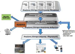
Figure 1 System Structure
A) The individual Concentration Measurement System, which collects data (after polling) from the Environmental Sensor Stations (ESS), which are located at predetermined points. The ESS is equipped with special sensors for collecting data on environmental conditions, such as sensors for measuring the weather conditions (sensors for tension / wind direction, temperature / humidity, rainfall, visibility / fog, etc.) and the state of the road (water, ice, snow) and clearly described below.
B) The sub-data management system. The subsystem includes the Control Center, which has the ability:
- to gather in a special database, processes the information gathered by the data acquisition system
- based on data collected from stations that are installed at selected points, to draw conclusions on the environmental conditions prevailing in the coverage area of base stations with special software,
- to transmit the necessary information to the Information Dissemination Subsystem for further diffusion of alternative channels described below.
Furthermore, the Control Center is to expand the operating characteristics and capabilities, while the connectivity with the corresponding centers of similar projects implemented with financing from the OP Information Society in the neighboring prefectures and weather forecasting applications.
C) The Individual Information Dissemination System, which is responsible for disseminating information to selected media players and distinct channels information. This includes both the necessary telecommunications equipment in the control center and special LED displays (VMS) that can been placed at strategic points in the default main entrances of the sub-national roads and website information to the public.
Procedure of information dissemination:
1. Receiving data from the Data Processing Subsystem and spreads based on specific rules and information channels to the ultimate consumers,
2. Indicates information messages and assumes the diffusion after the approval of the system,
3. In case of emergency provide specific information to specific groups and send the necessary messages.
Figure 2 below shows graphically how the Information System weather.

Figure 2 Operating System
The necessary data collected for processing, storage and viewing of the Control Center of which are promoted in the various channels of communication to inform special teams of qualified staff
Live demos :
http://fthiotida.stereahellas.gr/en
http://maliakos.stereahellas.gr/en.